The valley of the Aghstev River (Azerbaijani: Aghstafa-chay), encompassing the cities of Dilijan and Ijevan within the Republic of Armenia, and Kazakh and Aghstafa within the territory of Azerbaijan, has for several centuries served as the principal geographical corridor linking the Araks Valley and Yerevan (present-day central Armenia, home to approximately two-thirds of the country’s population) with the other two major centers of the South Caucasus—Tbilisi and Baku. During the period of the Russian Empire, the main highway connecting Yerevan to Tbilisi passed precisely through this route.
In the Tsarist era, the Russian Empire, as in other strategically significant regions, implemented the practice of resettling Russian sectarian communities along critical communication arteries and mountain passes of the South Caucasus. This policy was applied to the most challenging sections of the Yerevan–Tbilisi highway, particularly the Sevan Pass. It was the Molokan communities settled in this area who carried out freight transportation across the most difficult stretch of the route, inhabiting both the northern slopes of the pass (the villages of Golovino and Novo-Dilijan) and its southern slopes (Semyonovka and Sevan, formerly Yelenovka).
The situation changed to some extent following the construction of the Tbilisi–Alexandropol–Kars railway in 1899, which ran through the Lori Gorge, and later with the commissioning of the Alexandropol–Yerevan railway. Nevertheless, during the Soviet period, the prevailing logic persisted whereby the principal communications between central Armenia and the South Caucasus centers continued to pass through the Aghstev Valley. The M-24 highway (Yerevan–Dilijan–Kazakh) became the only road of all-Union significance traversing the territory of Armenia.
At the same time, from 1924 onward, the concept of a new Yerevan–Sevan–Aghstafa railway was actively debated. This line was intended to serve as a new trunk route, alleviating pressure on the Yerevan–Gyumri–Tbilisi and Yerevan–Nakhichevan–Baku directions. It was shorter than both alternatives—by approximately 90 km and 50 km, respectively. Another key advantage was its connection to the double-track Baku–Aghstafa–Tbilisi–Samtredia railway, which features a direct alignment, a low gradient (minimal elevation changes), and largely flat terrain, enabling significantly higher operating speeds compared to routes through the Debed Gorge or the alternative Nakhichevan–Meghri corridor.
In 1959, construction of the Yerevan–Kazakh gas pipeline commenced along the same corridor, which went on to become Armenia’s main trunk gas supply line. The electricity grids of Soviet Armenia and Azerbaijan were likewise interconnected through this section.
From the mid-1960s, construction began on the Aghstafa–Kazakh–Ijevan railway, which was completed in 1971. Ijevan became the terminal station of the branch located within the territory of Armenia and retained this status until 1986. In 1986, the Ijevan–Hrazdan railway was completed, linking the existing Yerevan–Hrazdan line with the Ijevan–Baku/Tbilisi railway corridors.
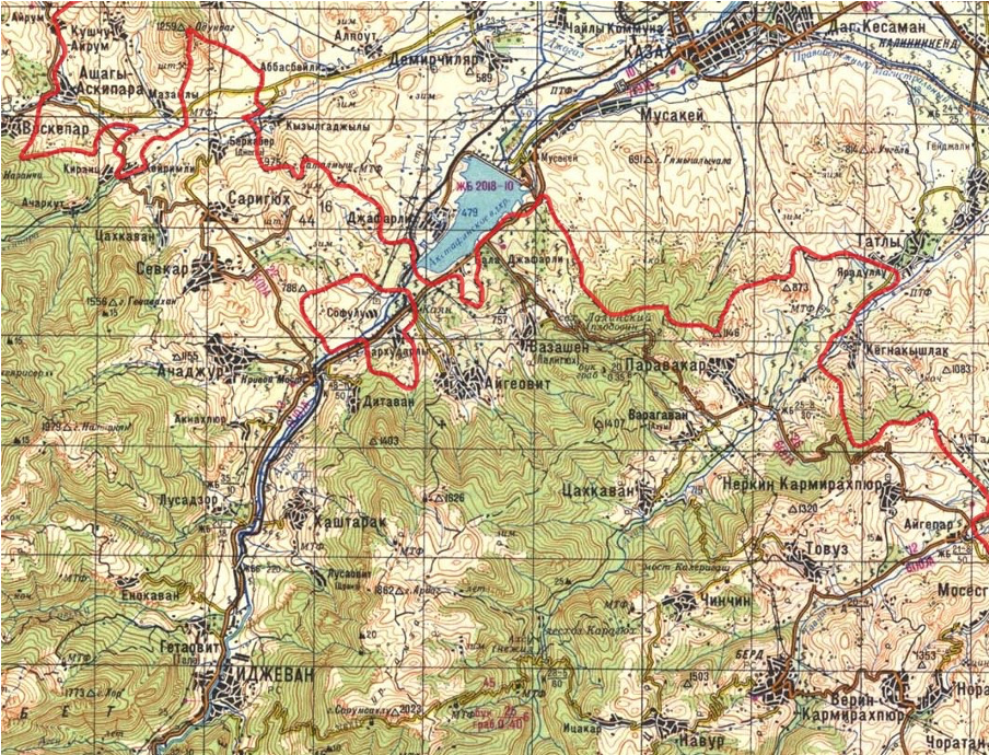
The Armenian–Azerbaijani Border (marked in red) and Transport Links in the Kazakh–Ijevan Zone, according to a 1974 Soviet General Staff map of the USSR Armed Forces. The Kazakh–Ijevan railway is also indicated.
Between 1972 and 1986, freight was transported up to Ijevan station and then distributed in various directions via Azerbaijan and Georgia. Within Armenia, cargo distribution from Ijevan was carried out using road freight vehicles. By the late 1980s, the volume of traffic along this line had reached over 900 trains and approximately 35,000 wagons per year—more than 3 million tons of freight. For comparison, this is roughly twice the volume of freight transported via Armenian railways in 2024.
From 1991 onward, both railway and road transport between Armenia and Azerbaijan along the Ijevan–Kazakh line ceased entirely. The border sections of the routes became zones of military operations, with positional shifts causing the line of contact to no longer coincide with the former Soviet administrative boundary. The Armenian side also assumed control over the territory of the **Sofulu–Barkhudarlu enclave**, through which the railway, highway, and gas pipeline pass. Military operations resulted in significant damage to the railway infrastructure and other transport communications.
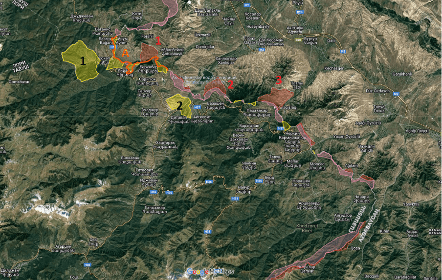
The situation in the Kazakh–Ijevan sector following the hostilities of the 1990s and the partial border delimitation carried out in 2021
Yellow indicates the administrative territory of the Azerbaijan SSR that came under Armenian control, including:
1. the Upper Voskepar (Yukhari Askipara) enclave, and
2. the Sofulu–Barkhudarlu enclave.
Red indicates the administrative territory of the Armenian SSR that came under Azerbaijani control, including:
1. the triangular area north of the Jogaz Reservoir,
2. the territory of the village of Vazashen, and
3. the occupied territory of the village of Paravakar.
Pink denotes the inter-positional area (neutral zone).
A– The situation in the Kirants–Voskepar area following partial border delimitation.
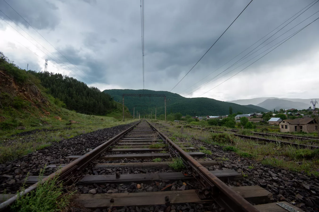
The section of the railway located within the territory of Armenia remained fully operational along its entire length until 1994, when a landslide damaged approximately 1.6 km of track south of the village of Haghartsin. However, the segments extending from the landslide site toward the Azerbaijani border, as well as those running in the Dilijan–Hrazdan direction, technically remained serviceable. Their subsequent degradation was primarily driven by the absence of demand for domestic freight transport and the gradual wear and deterioration of infrastructure. Until 2012, freight trains operated from Yerevan to Dilijan. After 2012, the Hrazdan–Dilijan section was also taken out of service, and the Meghradzor tunnel was placed under conservation.
The main factors contributing to the deterioration of the infrastructure can be divided into two categories: anthropogenic and natural. Anthropogenic factors include the dismantling and appropriation of signaling systems, overhead contact lines (copper), wooden sleepers, metal rails, and metal supports for contact lines—primarily for scrap metal resale or construction purposes. Natural factors include landslides, soil subsidence, erosion, settlement of the railway embankment, forest overgrowth, damage caused by wind and earthquakes, as well as infrastructure degradation resulting from metal corrosion and the decay of wooden sleepers.
From Kazakh station to the Armenian border, and further onward to Fioletovo, the railway can be divided into several sections based on the degree of damage.
The segment from Kazakh station to the Armenian border—approximately 14 km in length—shows increasing levels of damage as it approaches the border, with military engineering structures intersecting the railway line in its terminal sections. Rehabilitation would require reinforcement of the railway embankment, replacement of sleepers and rails, and restoration of overhead line supports and contact wires. The terrain is flat, the track profile is low, and accessibility is favorable, allowing this section to be restored relatively quickly.
The section located within Armenia can likewise be subdivided into several subsections. From the Azerbaijani border to the city of Ijevan, the railway is severely damaged, with key infrastructure components—including rails—missing along much of the route. In approximately one-third of this section, supports and rails have been preserved, though they are subject to full replacement. The total length of this segment is around 17 km, including approximately 2.7 km passing through the Sofulu–Barkhudarlu enclave.
The terrain consists of a wide valley along the Aghstev River, characterized by a low-elevation profile and a parallel highway, which significantly facilitates the delivery of construction materials and access for heavy equipment. From a geographical standpoint, this is one of the most favorable sections within Armenia, where rehabilitation would not pose major technical challenges and is estimated to cost approximately USD 100 million.
The segment from the city of Ijevan to the village of Haghartsin—where the landslide occurred—is the most complex in terms of topography, the presence of sophisticated engineering structures, and the nature of the damage. Large portions of the route are forested, and the line includes numerous bridges and viaducts (approximately eight), as well as tunnels—one beneath the city of Ijevan (2,960 m) and another south of the village of Hovk (approximately 990 m)—the technical condition of which requires separate and detailed assessment. This is the most expensive and technically demanding section to restore along the Hrazdan–Ijevan–Kazakh railway.
West of Haghartsin village, the preservation of railway infrastructure elements is significantly better. In the Dilijan–Fioletovo section, only minimal investment would be required to resume operations, as freight trains continued to run along this route toward Dilijan until 2012.
It follows from the above that the most feasible sections for rehabilitation are the Kazakh–Ijevan and Dilijan–Fioletovo–Hrazdan lines, while the most challenging segment lies between the cities of Dilijan and Ijevan, east of Haghartsin village, spanning approximately 25 km.
Based on this assessment, the restoration of direct Armenia–Azerbaijan railway connectivity could involve the rehabilitation of approximately 31 km of track across flat terrain, from Kazakh station to Ijevan station. Of this, about 14 km lies between Kazakh station and the Armenian border, while roughly 17 km is located within Armenian territory, including approximately 2.7 km passing through the Sofulu–Barkhudarlu enclave. Restoring this section would recreate the situation that existed between 1971 and 1986, when Ijevan served as the terminal station of the Kazakh–Ijevan railway.
At the same time, for the initial phase, reopening road connectivity between the two countries along the Ijevan–Kazakh highway is considerably more feasible. Approximately 2.4 km of this road also passes through the Sofulu–Barkhudarlu enclave. By rehabilitating the road segment between the Armenian settlement of Kayan and the Azerbaijani village of Bala Jafarly (around 2.1 km), it would be possible to establish direct communication between the two countries. If this is accompanied by the parallel opening of the Armenian–Turkish border and the Akyaka–Akhurik crossing, this route would become the shortest road connection between Turkey and Azerbaijan.
Although the Kayan–Ijevan–Dilijan–Vanadzor highway is classified as a third-category road, and the subsequent Vanadzor–Gyumri segment may be classified as second-category—implying limited capacity—the current traffic load suggests that, in the initial years following border openings and the activation of Armenia–Azerbaijan–Turkey transit, it would be able to accommodate freight volumes without significant difficulty. Moreover, this route offers geographical advantages absent from all alternative corridors via Georgia, southern Armenia (Meghri), or Nakhichevan. Consequently, in the medium term, this corridor should be developed in line with an East–West strategic logic through the construction of a first-category, international-standard highway (four lanes—two in each direction), which could become the principal transport artery of the South Caucasus.
The restoration of the gas pipeline between Azerbaijan and Armenia would likewise require the rehabilitation of approximately 15 km of pipeline between the two countries and could therefore represent one of the fastest infrastructure projects to implement in practical terms.
The Issue of Communications and Border Delimitation
In the context of opening communications between the two countries, one of the frequently advanced arguments is that the launch of transport links requires prior delimitation and demarcation in those sections where communications cross the state border. This is deemed necessary for purposes such as demining border areas, clarifying the placement of border checkpoints, and addressing related security and administrative concerns. Despite the internal logic of this argument, in the Ijevan–Qazakh section its full implementation is not feasible in the coming years for a number of reasons. At the same time, it is precisely in this section that the establishment of the most efficient direct transport links between the two countries—including rail connectivity—is both important and practically expedient.
The reasons why the opening of communications in this section cannot be made conditional upon the full completion of delimitation and demarcation are as follows:
1. The existence of the Sofulu–Barkhudarlu enclave, through which pass approximately 2.7 km of the Ijevan–Qazakh railway line and around 2.42 km of the highway. Since the issue of enclaves constitutes one of the most complex components of Armenian–Azerbaijani border delimitation, tying the opening of communications to the resolution of enclave-related disputes could delay the process for years. Such a delay would significantly undermine the potential for the development and deepening of relations among regional states (Turkey, Armenia, Azerbaijan), including the realization of the key and shortest West–East transport corridors.
2. The connection of the Azerbaijani village of Bala Jafarli to Azerbaijan’s main territory and the problem of the Ijevan–Qazakh road, which, after exiting the village, crosses the Armenian border several times before re-entering Azerbaijani territory. In the early 1990s, the Azerbaijani side took control of the entire protruding section of Armenian territory east of Bala Jafarli through which the road to Qazakh passed, thereby ensuring the village’s connection with “mainland” Azerbaijan.
3. The issue of the Armenian settlement of Kayan located within the Sofulu–Barkhudarlu enclave, as well as a small section of the Azatamut settlement. According to delimitation arrangements, even in the event that the enclave is returned to the Azerbaijani side—under a scenario of reverting to Soviet-era enclave-based borders—solutions must be found for the existing settlement. These solutions would entail optimizing the enclave’s boundaries in this section, meaning that the settlement would remain within Armenia in exchange for territorial compensation of equal size to Azerbaijan. Consequently, a return to Soviet-era borders in this area—particularly regarding the enclave and the Armenian territory east of Bala Jafarli currently occupied by Azerbaijani forces—would generate a number of serious communications-related problems, including the need for repeated border crossings.
In this context, a possible solution could be as follows: the parties would carry out sectoral border delimitation along the railway section and between the settlements of Kayan and Bala Jafarli, reverting to the former administrative boundary. In this arrangement, the entire highway east of Bala Jafarli that passes through Armenian territory would remain de facto under Azerbaijani control, in the same manner that the Sofulu–Barkhudarlu enclave would remain under Armenian control. The opening of communications would presuppose the establishment of railway and road border checkpoints in the Kayan–Bala Jafarli section. The Armenian side would restore all communications located within its territory and within the enclave, while the Azerbaijani side would do the same within its own territory and in the section east of Bala Jafarli under its control (where the road is currently also suitable for operation).
Thus, irrespective of the final status of the enclaves and the area east of Bala Jafarli, transport communications could be put into operation pending the achievement of comprehensive and final settlements on these outstanding issues.
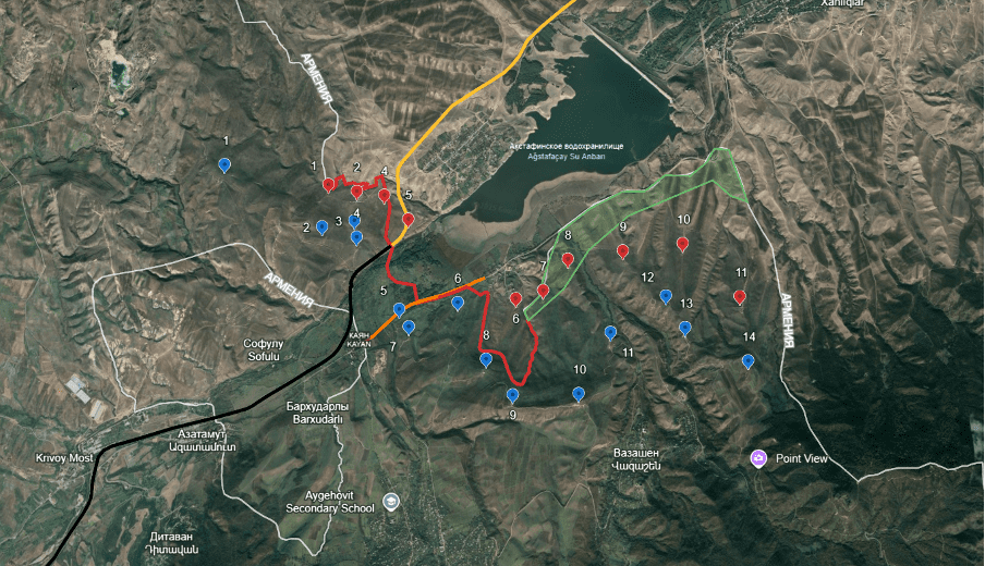
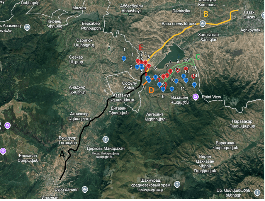
General and Detailed Maps of the Proposed Solutions
A – The Ijevan–RA border railway line, including the section passing through the enclave territory
B – The RA border–Qazakh railway line
C – The section of RA territory that could remain under Azerbaijani control in order to ensure the connection of the village of Bala Jafarli with “mainland” Azerbaijan (approximate)
D – The Kayan–Bala Jafarli highway section (2.1 km), the restoration of which would make it possible to establish direct road connectivity between the Republic of Armenia (RA) and the Republic of Azerbaijan (AZ)
E – The portion of the border subject to sectoral delimitation required for the activation of transport communications
Blue markings – Armenian military positions (current)
Red markings – Azerbaijani military positions (current)
Under such a scenario, direct Armenia–Azerbaijan railway connectivity would become feasible following the restoration of the Qazakh–Ijevan railway line (approximately 31 km). This line runs through favorable terrain, along the lowland of the lower course of the Aghstev (Aghstafa) River, with minimal elevation differences and a low railway profile. In this case, Ijevan railway station could be transformed into a multimodal freight terminal, from which cargo transported via the Baku–Qazakh double-track railway could be redistributed throughout the territory of Armenia by heavy-duty trucks.
In the longer term, this would also make it possible to significantly ease the load on the southern route via Meghri, which—due to its geographic characteristics—inevitably faces structural limitations on freight volumes. While the Meghri corridor is critically important for the Armenian side in terms of connectivity with Syunik and the rail export of mineral resources, it is considerably less suitable for central and northern Armenia, where approximately 95% of the country’s population is concentrated. By contrast, the Ijevan–Qazakh corridor represents the most optimal route for Armenia’s direct connectivity with Azerbaijan and Georgia.
According to our assessment, the restoration of the 31 km railway section between Ijevan and Qazakh can be completed within 1 to 1.5 years, while the rehabilitation of the approximately 2.1 km road segment required to restore automobile connectivity between the two countries along the same axis would take less than one month.